Outdoor weather stations are essential tools for monitoring and researching meteorological changes. They provide long-term and stable monitoring of various environmental parameters, covering not only fundamental data such as temperature, humidity, and atmospheric pressure, but also dynamic information including rainfall, wind direction, and wind speed. Among these numerous meteorological parameters, evaporation is a critical observation indicator. It carries significant weight in evaluating the hydrological cycle, agricultural irrigation, and water resource management. This article will explore in depth how outdoor weather stations obtain accurate evaporation parameters.
What is Evaporation?
Evaporation refers to the volume of water that transforms from a liquid state into a gaseous state within a specific timeframe. It is typically measured by the depth of the evaporated water layer, with the standard unit expressed in millimeters (mm).
The evaporation process is influenced by various environmental factors, including temperature, air humidity, wind speed, and atmospheric pressure. Generally, the rate of evaporation becomes more intense when temperatures are higher, air humidity is lower, wind speeds are greater, or atmospheric pressure is lower.
Why Do Weather Stations Monitor Evaporation?
The integration of evaporation measurement into outdoor weather stations is primarily driven by three critical objectives:
Understanding the impact of the water cycle on meteorological changes
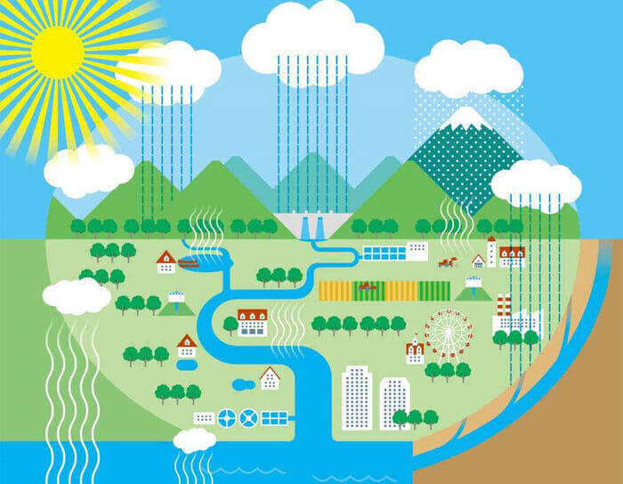
The cycling of water between the surface and the atmosphere is a fundamental component of Earth’s climate system, and changes in this cycle both reflect and amplify climate change. According to the Intergovernmental Panel on Climate Change (IPCC) Sixth Assessment Report, warming increases the amount of moisture that the atmosphere can hold, altering patterns of precipitation, soil moisture, and surface energy balance. As global temperatures rise, even without a significant decrease in precipitation, increased evaporation can reduce soil moisture and exacerbate drought conditions, a phenomenon becoming increasingly common in warming regions globally.
Optimizing agricultural irrigation and water use efficiency
Studies show that scheduling irrigation based on local climatic conditions and moisture demand can significantly increase water use efficiency and crop productivity, especially in arid regions. Accurate monitoring of evaporation informs decisions about irrigation timing and method, enabling techniques like drip or micro-irrigation to minimize non-beneficial water loss. Climate models and field experiments confirm that ignoring these losses can lead to substantial water waste and reduced yield, particularly under variable weather patterns. By integrating real-time evaporation data with soil and crop information, farmers can optimize water application, ensuring that crops receive adequate moisture while conserving limited water resources.
Providing scientific data for water resource management and drought warning
A study by UCLA and National Oceanic and Atmospheric Administration climate scientists has found that evaporation accounted for 61% of the drought’s severity, while reduced precipitation only accounted for 39%. Research has found that since 2000, evaporation demand has played a greater role in drought than reduced precipitation, becoming the biggest driver of drought severity and area expansion.
How Outdoor Weather Stations Measure Evaporation?
Measuring evaporation at an outdoor weather station is not a simple observation of water “disappearing.” Instead, it involves scientific methods for the quantitative acquisition of the volume of moisture transferred from the ground or a container surface into the atmosphere per unit of time (typically expressed in mm/day or mm/hour). These measurement techniques are categorized into three main types, each designed to meet the requirements of different application scenarios:
1. Traditional evaporation pan method
Using an evaporating dish is a common manual measurement method. It consists of a moderately deep, wide-mouthed container and a measuring device. To use it, place the container in the area where you want to measure, and add a specific amount of water. Then, place the measuring device on the water surface to record the depth it sinks or the distance the marker moves. Finally, the evaporation rate is calculated using a formula based on the data.
The measuring container should have a smooth surface, be corrosion-resistant, and have uniform thickness, so as not to affect the surface tension of the evaporating water. Since the principle of the evaporating dish is to measure the evaporation amount by evaporating water, the external conditions should be controlled during use to avoid a large amount of water outside the evaporating dish, which will affect the accuracy of the measurement.
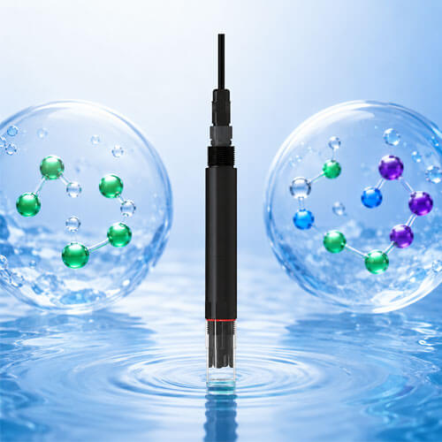
2. Evaporation sensors
While an open water surface provides the ideal environment for measuring evaporation, practical implementation presents numerous logistical challenges. Consequently, weather stations typically utilize specialized evaporation sensors for consistent observation.
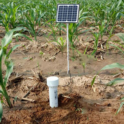
This equipment consists of a metal cylinder with a standardized diameter and depth, which holds a specific volume of purified water. After a 24 hour interval, the device measures the reduction in water volume caused by evaporation, allowing for the calculation of the total daily evaporation rate.
The evaporation sensor is a commonly used measuring device in outdoor weather stations. It works on the principle of pressure measurement, which calculates the evaporation of water by detecting the weight change of the liquid in the container. This sensor can not only automatically monitor data, but also adapt to various outdoor environments and is not affected by liquid freezing. It can be used with a rain snow sensor, rain gauge, etc. to realize automatic rainfall monitoring.
The RS-EVA-*-2-EX evaporation sensor, independently developed and manufactured by Shandong Renke, can be easily integrated into weather stations and uploaded to data platforms alongside monitoring results from other meteorological sensors.
This sensor effectively avoids the errors inherent in traditional float or ultrasonic types caused by factors such as freezing, wind force, or direct sunlight interference. It operates stably even in harsh environments, providing a cost-effective choice for continuous, high precision evaporation measurement.
3. Estimation methods integrated with other weather parameters
For the combined process of moisture loss from the ground surface and plant surfaces known as evapotranspiration reference to multiple meteorological variables is required. Modern automatic weather stations are widely equipped with sensors for temperature relative humidity wind speed and solar radiation. The parameters they provide form the foundation for estimating evapotranspiration through physical models.
A standard practice is to utilize energy balance or the Penman Monteith equation. This method combines factors such as net radiation air temperature humidity and wind speed to back calculate evapotranspiration volume via physical models. Rather than simply measuring a single variable this process relies on algorithms executed either within the weather station or on a backend platform to calculate real time output based on how each meteorological variable influences the rate of moisture entering the atmosphere.
The core advantage of this integrated approach lies in its ability to provide broader evapotranspiration information particularly for applications such as agricultural irrigation and water resource management. By collecting data on temperature humidity radiation and wind speed through automatic weather stations and applying standard algorithms like Penman Monteith users can obtain data that more closely reflects actual surface moisture loss while supporting remote monitoring and data platform analysis.
Key Factors Affecting Evaporation Rates
The evaporation rate is not determined by a single factor but is the result of the combined action of various environmental variables. Understanding these core factors not only assists in precise evaporation measurement but also explains why modern outdoor weather stations typically integrate multiple sensors such as temperature humidity wind speed and solar radiation.
1. Temperature
Air temperature is one of the most direct driving forces of evaporation. The transition of water molecules from a liquid state to a gaseous state requires energy known as latent heat. Higher temperatures increase the probability that water molecules gain sufficient energy to overcome surface tension thereby accelerating the evaporation speed. Outdoor weather stations use high precision temperature sensors to monitor air temperature in real time providing fundamental thermal energy information for evaporation estimation.
2. Relative humidity
The humidity of the air determines the capacity for water vapor to diffuse into the atmosphere. When the air has high water vapor saturation or high humidity it means the air already contains a large volume of water vapor and is near a saturated state. In this situation the process of water molecules converting from a liquid to a gaseous state is inhibited because the air can hardly accommodate more water molecules. Relative humidity and temperature together influence the evaporation potential of the air so weather stations must monitor both parameters simultaneously to calculate the true evaporation rate.
3. Wind speed
When wind makes contact with a liquid surface it carries away the moisture above that surface. Wind speed enhances the evaporation process by continuously removing evaporated water vapor and increasing the diffusion rate of water vapor in the air. In calm wind environments the air near the water surface easily becomes saturated creating evaporation resistance whereas in windy conditions this resistance is weakened. Therefore wind speed sensors are an essential component for estimating evaporation.
4. Atmospheric pressure
When the air pressure is high, it means the air density is greater, and the diffusion rate of water molecules from the water surface to the air is slower, which naturally slows down the evaporation rate. When the air pressure is low, it means the air density is relatively lower, allowing water molecules to diffuse more easily into the air, which increases the evaporation rate. Low atmospheric pressure means there are fewer water vapor molecules in the same space, making it easier for water molecules at the surface to escape. This is similar to an empty bus, where passengers waiting for the bus can easily get on, but when the bus is full, the waiting passengers cannot board.
5. Solar radiation
Solar radiation provides the essential energy required for water evaporation. The higher the radiation intensity the more energy moisture absorbs per unit of time which subsequently increases the diffusion rate. Weather stations utilize radiation sensors to collect data that can accurately reflect the impact of sunlight on evaporation.
What Users Do with Evaporation Data?
1. Scientific research (Estimating water balance and climate change analysis)
Through long term monitoring of evaporation from lakes rivers and soil surfaces researchers can evaluate the relationship between precipitation and runoff. This supports the establishment of hydrological models and climate models.
2. Agricultural irrigation optimization and water saving management
In arid or semi arid regions combining soil humidity with weather parameters allows for the formulation of scientific irrigation plans. This prevents over irrigation and the waste of water resources.
3. Reservoir dispatch and water loss optimization in engineering projects
By precisely monitoring evaporation rates hydraulic engineers can predict changes in water levels and optimize flood discharge or water storage operations. This ensures the safety of water supplies and improves water resource use efficiency.
4. Urban planning and ecological risk assessment
By analyzing evaporation data urban planners can optimize green space layouts wetland protection and rainwater management strategies. This reduces ecological risks and enhances the environmental sustainability of cities.
The Renke technical team consists of senior hardware engineers and software architects who always remain at the forefront of environmental sensing technology. We focus on the end to end development of environmental monitoring systems covering every stage from sensors and the Internet of Things to data platforms. At Renke we do not just manufacture equipment we are committed to creating precise engineering technology. Our mission is simple: Focus on the user and capture every degree of change. We provide customized one stop monitoring solutions for global customers helping various industries obtain the reliable data required to achieve excellent environmental control.